John Hasell Map Collection

TOD TO TODD AND BEYOND
VICTORIA AREA
HIKING MAP COLLECTION
ALL VOLUMES (1-9)
By
JOHN HASELL
January 2011
PURPOSE
These maps have been developed by John Hasell. Their purpose is to help experienced and responsible hikers find their way to interesting places, to identify particular features and to limit environmental damage to this beautiful landscape by indicating appropriate routes that will avoid the development of random paths. These nine volumes will identify the jpeg filenames of any maps you may wish to print or download.
NAVIGATION [adapted for the web]
Hyperlinks are designed to help you move from the index to any volume and back, and to any map within that volume. Maps open in full screen; use the browser back button to return to this page.
DISCLAIMER
The trails marked on these maps have all been used by the author who, where appropriate, had sought permission to use them. They do not necessarily represent public paths and their use may not automatically be permitted. The trails around Glinz Lake are on Y property (Camp Thunderbird) and should only be used after obtaining permission from the Y in Victoria (250-386-7511). Likewise trails passing through Camp Barnard should only be used after obtaining permission from the Boy Scouts (250-642-58240). The country itself is often wild and the slopes steep and slippery. The author accepts no responsibility for the safety of those using these maps and urges people to take full responsibility for their own actions including their personal safety. This definitely is not a Guide Book.
Index
VOLUME ONE – INTRODUCTION and GENERAL AREA MAPS
- 1. General Area Maps
This collection concentrates on the parks shown in this map and in particular on the wild country between Tod Creek flowing into Tod Inlet in the north to where Todd Creek flows into the Sooke River by the Potholes.
Description of CRD Regional Park Boundary Maps:
The 2,000 hectares shown in purple is the latest CRD Park acquisition (2010). This area includes Todd Creek and all of the Harrison Trail, Empress Mountain and the entrance to Charters Creek, through the Waterboard land and up via Crown Land to Grass Lake.
The bright green in proximity to the purple is the previous acquisition which included Peden Bluff and Lakes, Flower Ridge, Puzzle Peak and Emperor Mountain.
Red shows Crown Land which is being transferred to the CRD as Park, and the yellow green along the east bank of the Sooke River is the Sooke Potholes Park.
The pale green with a tree in the middle of it is Sooke Mountain Park, and the just a little darker green area on the right hand side of the map is Goldstream Provincial Park.
The dark green is The Sea to Sea Green Blue Belt Regional Park Reserve that includes Manuel Quimper and the area north of Shields Lake. The electric green on the right half of the Map is the Sooke Hills Wilderness Regional Park Reserve including The Amigos, Braden, McDonald and Mt Wells.
The light aquamarine is the Camp Thunderbird YMCA property.
The darker aquamarine across the top of the map and stretching South-East to Humpback Reservoir is the Water Catchment Area which will continue to be out of bounds. The lighter blue area towards the left of the map is also Waterboard Property that includes the Charters Creek Reservoir and the disused Flowline Header Tank. This critical piece of land is being handed over to CRD Parks. The black line is the Galloping Goose.
The Mexican brick red areas are private land, mainly to the west, south and east of the Blue Flowline but also including most of Ragged Mountain. I am not sure who owns the area south of Jack Lake, but we now have access to just about every part of the Sooke Hills that lie within a day’s easy walk from the highway. What a wonderful result. Many congratulations to all the people with the vision and determination to make this happen.
01c Sea to Sea Labelled Boundary Map
This map shows the names of these park acquisitions and the other lands in the area.
Description of Todd Creek Boundary Map
This enlargement specifically shows the 2010 CRD Park addition and identifies the key features and just some of the many trails that are now included in the Park.
The bright green indicates the new acquisition. Blue is the Waterboard Property and red shows the Crown Land. The grey green areas are the original Sea to Sea Green Blue Belt Regional Park Reserve and the darker green shows the areas added to the Reserve a couple of years ago. Pink is Private Land including Deer Hill and The Boneyard Ridge which form the backdrop to the Sooke Potholes Park which is marked in yellow.
What links these areas together are the Harrison and Charters Creek Trails from Sooke River Road through the recently acquired Western Forest Products lands and The Wonder Trail we have created from Harbourview Road to the 4 lane section of the Sooke Highway (#14).
GRID REFERENCES
It is important for any hiker to be able to identify their exact position when navigating in wild country. You may want to pass on this information to your friends, and in an emergency situation rescuers will need to know your exact location. Many hikers carry a GPS which shows them where they are and generally this enables them to read off either their Latitude and Longitude or a Grid Reference.
I decided that Grid References were easier to calculate on a map as they are based on 1 km squares which visually can easily be divided by ten into 100 meter segments. Lat Long on the other hand creates rectangles that are more difficult to calculate visually on a map. I have therefore added a grid to all my maps that cover wild country.
I have used the North American Datum 1983 NAD 83 (WGS84) Universal Transverse Mercator Grid system. For those using older maps that display the NAD 27 (1927) UTM Grid, you will need to add 97 meters to your Eastings and add 198 meters to your Northings.
I use Garmin’s MapSource and TopoCanada Maps Version 2 to create my maps. While MapSource does not actually display a grid, a small window displays the grid reference of the cursor very accurately as one moves it across the map. i.e. the Grid Reference for Willis Point is shown as being 464039 5380696.


For those unfamiliar with Grid References, you identify the square in which the place you wish to refer to lies. You take the North/South line that forms the west or left hand side of this square which is referred to as an Easting (It lies to the east of the point of reference for the grid system). In the case of Willis Point this is less than 50 meters to the east of the 64 Easting (640). The Northing is measured North from the horizontal line that forms the bottom of the square concerned. Again you judge the number of 100 meters north of this line which in this case is 7 (807) for a grid reference of 640 807. (64,039 meters East of the 400 Km Easting and 80,597 meters North of the 5,300 Km Northing. If using NAD 27, the grid reference for Willis Point would be 543 609.
Grid References are usually displayed as 6 figure numbers without a space. i.e. Grid Reference 640807.
An easy way of remembering that you measure the Easting before measuring the Northing is to remember the name of the E&N Railway or that you have to go into the house before you can climb the stairs (In from the Left and then up).
This is part of the printed map (1999) that I used to confirm the correct positioning of my grid squares.

The Northings are shown faintly just to the right of the 50 Easting, starting at 59 in Sooke Basin.
This helped me produce maps with grid squares marked on them, such as the following
These two maps show the major features in the West and East Sooke Hills respectively.
01g The Sooke Hills West – UTM Grid
01h The Sooke Hills East– UTM Grid
The grid squares form a continuous mesh across the whole area. Thus both maps show Crabapple Lake at 515680.
This map shows a suggested system of corridors that would provide a core network of hiking, biking and horse riding trails. This system makes use of a number of existing trails and includes a series of loops that provide different return routes. The blue squares indicate where bridges or fords and stepping stones are needed. The white lines indicate existing trails with black lines showing where these are currently in good shape. The yellow lines show where trails need to be developed to complete the system. Where possible these follow the lines of old logging roads. Note that the system requires the acquisition of, or rights of way through, the Kapoor Lands that are not yet included in the parks.
VOLUME TWO – WEST OF SOOKE
- 2 Juan da Fuca Trail
02a Juan de Fuca Trail China Beach-Mystic Beach – km 0 to 5
02b Juan de Fuca Trail China Beach-Magdalena Point – km 0 to 14
02c Juan de Fuca Trail – Bear Beach – km 5 to 14
02d Juan de Fuca Trail -Magdalena Point – Chin Beach – km 13 to 25
02e Juan de Fuca Trail – Sombrio – km 23 to 29
02f Juan de Fuca Trail – Parkinson-Sombrio – km 26 to 38
02g Juan de Fuca Trail – Botanical-Parkinson-Sombrio – km 30 to 47
02h Juan de Fuca Trail – Botanical-Parkinson – km 38 to 47
- 3 Kludahk Trail
The Kludahk Trail is a public trail that runs 48 km along the San Juan Ridge, which parallels the Juan de Fuca Straight between Jordan River and Port Renfrew. For the most part the trail is located on crown land, two thirds of it is located on TFL 25, the other third, the eastern section of the trail, is located on private lands. The trail is protected under a special designated management zone developed by the Ministry of Forests in partnership with the forest industry. The trail and its five cabins are managed by the Kludahk Club http://www.kludahk.com/index.html who should be notified whenever you plan to hike over any portion of it, e-mail :- <info@kludahk.com>
03b Kludahk Master Overlay Map
03d Kludahk Trail 2 – Center West
03e Kludahk Trail 3 – Center East
- 4 The Matterhorn and Muir Creek
04a Matterhorn Mountain Trails
This beautiful trail is in the process of being ruined as clear-cutting continues up to the Hydro L:ine right of way.
The usual route starts at The Eagle Lights General Store through a gate to its right. The other route starts up Juan de Fuca Road and on up through Priest Camp Park. This is the route used by motorcyclists.
You can park your car on the bit of roadway immediately east of the bridge over Muir Creek.
VOLUME THREE – NORTH and SOUTH OF SOOKE
- 5 Camp Barnard:- Bluff to Trap Mountain – The Parrot – Boneyard
Access to this area is through the Boy Scouts of Canada’s Camp Barnard. Phone 250-642-5924 and then park in the large car park just north of the lake and the Caretaker’s Cabin.
North of the Car park is a small field at the top end of which the Bluff Trail starts into the woods.
Just before this field, the road curves to the left and is the Access Road to the trails leading North into the hills between Bluff and Trap Mountains.
Opposite the car park and to the north of a playing area is a road that leads past the kitchen and dining hall area. This leads past a beautiful gorge and up a rubble bank onto Butler Main. From here you can gain access to The Parrot and below it, across B&B Ridge to the trail up onto The Boneyard Ridge.
05a Trap to Sooke River Trails
- 6 East Sooke Park
There are car parks at Aylard Farm and Iron Mine Bay Road and a good hike is to swap cars at either end. Access is possible from the East Sooke Road onto the Endurance Ridge Trail, up from Anderson Cove to the start of the Babbington Hill Trail, or up through the housing estate to the west of it that takes you to the north end of the Coppermine Trail. Cabin Point makes a good turnaround point with the choice of a coastal or interior route.
The Coastal Trail is a magnificent but quite challenging hike.
- 7 Matheson Lake – Roche Cove
Take the 1A from Victoria onto the Old Island Hwy (14) turn left on Metchosin Road, keep left of the Welcome to Metchosin sign. Turn right on Happy Valley Road at the Metchosin Cafe (the covered wagon) then left onto Rocky Point Road and Right again onto Matheson Lake Park Road, just before you get to Pedder Bay.
Alternatively you can take Highway 14 towards Sooke and turn right onto Gillespie Road soon after passing the 17 Mile Pub. Park at the Galloping Goose Car Park on the left just before crossing Roche Cove
07a Matheson Lake – Roche Cove
- 8 Metchosin Area Parks
Metchosin provides a number of small parks, mostly interconnected by grass verge hikes and one section of tarmac. There are two connections with Matheson Lake Park
VOLUME FOUR – SOOKE RIVER ROAD (Potholes and Charters Creek)
- 9 Peden Bluffs – Three Bears – Black Bear – Mary Vine Trail – Flower Ridge – Lakes Carriageway
Access is from the Upper Sooke Potholes Car Park to the Flowline, either up the Waiting Room Trail or the Lower Mary Vine Trail. An alternative is to ascend the Lower Flower Ridge Trail from the top of the col on the northern end of the Horse bypass by the Trestle Bridge close to the lower Sooke Potholes car park.
Sooke River Road runs 4.6 km north from Highway 14 – The Sooke Road – just before the highway crosses the Sooke River about 38 km out-of-town.
The Car Parks in The Sooke Potholes Park provide access to the whole area around Todd Creek and Peden Bluffs., with the flowline providing a number of start points into the area.
- 10 Sooke Potholes – Larkspur – The Plateau Trail
The best place to park to get onto the Todd Creek Trail is just off the tarmac on the western side beside the river 100 meters before the gate into the Sooke Potholes car park. The Todd Creek Trail starts through the lacked gate on the east side of Sooke River Road and has been badly washed out. The trail proper starts on the far side of the Galloping Goose.
10a Todd Creek and The Lakes Trails
10b Todd Creek and The Lakes Air Photo
10d Trails to Empress-Emperor Mountains
- 11-12 Todd Creek – Emperor Mountain – Empress Mountain – Harrison Trail
11a Sooke River to Grassy Lake Trails
12a Charters Creek – Grassy Lake Trails
This is the same map as the previous one but is included to emphasize the Charters Creek entrance. Park on the side of the road just south of the bridge over Charters Creek, or at the Salmon enhancement site up Charters Creek
VOLUME FIVE – HARBOURVIEW ROAD and GLINZ LAKE
- 13. Harbourview Road – Milne Peak – Manuel Quimper
Access to this area is from the CRD car park at the northern end of Harbourview Road at the point where it officially becomes Sooke Mountain Park Road. Harbourview Road runs North from Highway 14, the Sooke Highway, about 33 km out of Victoria. Look out for the bridge over Ayum Creek and take the next turning right.
13a Manuel Quimper Area Trails
This map shows the areas of private property in green that, if acquired by CRD Parks, would enable public access to the Manuel Quimper massive from the south and east and put the Wonder Trail within the park.
There is a maze of old roads to the west of Manuel Quimper and this map gives you some idea of their complexity. A priority should be the construction of a bridge across Charters Creek to the west of The Bear Patch that would connect this area of the park with the trails leading up to Grassy Lake.
- 14 The Wonder Trail from Harbourview Road to Humpback Road
The Wonder Trail was designed and cleared by The Wednesday Wonderers as a major connecting trail across the Sooke Hills. It starts at the Harbourview Road Car Park, goes through the gate to the right and climbs up and back under the hydro lines. When you reach the flowline, instead of going straight on up the South Trail of Manuel Qimper, turn right onto the Flowline. Follow this for a kilometer before stepping down onto a rock between the pipe and the land to the north. A zig will take you back under the hydro line and onto the trail leading north.
Just before the trail breaks out of the trees into a very wet spot, follow the tape into the salal on the right, cross the stream and get onto the open slopes above Ayum Creek.
14b Wonder Trail West – Harbourview to Glinz Lake
This map shows the western end of The Wonder Trail which traverses open benches above the Ayum Creek Canyon that have never been logged.
The YMCA discourages the public from entering their property (shaded in aquamarine), being concerned for the safety and security of their campers. We encourage people to access the area via Harbour View Road from the West or The Wonder Trail from the East. The summit of Ragged is privately owned as shown in brown.
As you will see there is a trail along the top of Dinosaur Ridge West that you can follow along to Crow’s Nest. On several occasions we have hiked directly down from it to the South end of the Ambulatory Patient’s Trail and returned by it, or the Jurassic Park Trail, to get back onto the Veitch Carriageway. The southern end of Hydro Ridge, opposite Buck Hill, has a fine cliff which we call Eagle Lookout. From it you can bushwhack to The Fish Ponds on Impala Road and thence over Sugarlump and Camas Ridge to the Veitch Carriageway.
14c Wonder Trail East – Glinz Lake to Aggressive
This map shows the section of The Wonder Trail in purple from Glinz Lake (The YMCA’s Camp Thunderbird) to Aggressive, as well as The Secret Trail which is a parallel trail that we also pioneered that goes up the Veitch Carriageway (the old Waterboard Road) and then turns off westward just before the Hydro Lines. The green lines are the principal trails that branch off from The Wonder and Secret Trails.
We sometimes leave our cars at the Humpback Road intersection and then take the bus to Harbourview Road. The total distance is about 15 km and is an easy day’s hike.
The one area of CRD Parkland which is being opened up to the public is Manuel Quimper
- 15 Sooke Mountain Park
15b Sooke Mountain Park Trails
- 16 Glinz Lake – Y Camp Thunderbird Trails
- 17 Thunderbird – Ragged Mountain
17a The Trails Round Mt Ragged
17c The Trails on Ragged Mountain
17d The Connector Circuit Round Ragged Mountain
VOLUME SIX – SOOKE 4 LANE HIGHWAY – THE LETTERBOXES & AGGRESSIVE
- 18 The Veitch Letter Boxes:- Sugarloaf – Sue’s Trail – Townsend Ridge – Badlands – Secret Trail
The only public access to this part of the yet to be officially opened Park Reserve is along The Pleasant Path. This starts north of the Letterboxes just past the Logging Mill at the hydro pole crossing of Highway 14.
18a Townsend & Sugarloaf Trails
18b Camas and Sugarloaf Trails
An alternative entrance to the Veitch Creek area is through the Aggressive Entrance. This is a blocked off gravel road just west of the Humpback intersection with Highway 14, The Sooke Road. There is a sign on a mast covered by a real estate agents plastic sign. The owner of the property is Russell Crawford, 250-478-5035, and we let him know when we plan to use his entrance to The Amigos
This is a pleasant alternative to the Wonder Trail and it leads directly to the trail into the North Dinosaur Range.
- 19 Aggressive:- The Upper and Lower Amigos – Mount Braden
Many people enjoy hiking in the Lower Amigos area in from Aggressive and is a great area in which to introduce visitors to the Sooke Hills.
19c Mount Braden Amigos Trails Map
This map shows half a dozen trails that lead to the seven summits of Mt Braden. The South West Trail is one of the better routes with great views, and the traditional South Route provides a swift descent. The two trails coming in from the North provide a longer way up, and the East Trail over Plateau Peak provides a steep and interesting way to the top. The Cowichan Canyon Route is not recommended except for the most intrepid.
19d Braden – Amigos – Dinosaur Trails
- Centre Mountain
20a Centre Mountain Golf Course Routes
This is an interesting area in which to hike. Access is either from Woodruff Road and Gilmour opposite the Humpback intersection with the Sooke Highway (14) that leads to a large quonset hut to the west, or from Happy Valley Road to the east. When travelling south on Happy Valley Road, turn right onto Neild and look for a metal wired gate on the right just after crossing the Metchosin River opposite a large house with annex. The owner of the property lives in the house on the right on Neild Road just before you cross the stream.
VOLUME SEVEN – HUMPBACK ROAD – GOLDSTREAM
- 21 Mt McDonald
The best place to park for a hike along the Mt McDonald Trail is to drive south on the Humpback Road from the Car park by the reservoir, over the humps, past the wetlands on the right and stop at the first possible parking area on the right soon after entering the forest. You will see a row of stones just ahead of you with a No Entry Park sign beside them. This is the start of the trail. You can no longer return south down the private road beyond Mt McDonald as this has been decommissioned with the construction of the new access road going North by Nor’west from the col between Marnie and Hugh’s Heights
21a Mt McDonald – Upper Amigos Trail
21b Trails & Roads round Mt Braden, McDonald, Wells
- 22 Mount Wells
22a Mount Wells Regional Park Trails
- 23 Goldstream Park – Mt Finlayson
23b Mt Finlayson – Caleb Pike Trails
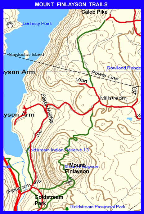
- 24 The Gowlland
The main access points to this hiking area are shown by the red Car Park signs
24a Gowlland North – Mt Work Trails
24c Mackenzie Bight – Rabbity Trail
- Partridge Hills
This second map, in landscape, prints much larger than the first, but does not cover the dead-end Tod Inlet Side Trail.
25a Partridge Hills – Durrance Lake – Tod Inlet
25b Partridge Hills – Durrance Lake

ACTIONS REQUIRED TO MAKE THIS INTO A VIABLE PUBLIC PARK
The map on the left shows areas of private land in red that should be incorporated into the park to provide reasonable public access.
The red dot at the eastern end of Tod Inlet shows where a bridge across Tod Creek is needed to connect the two parts of the park.
- Mount Work
VOLUME EIGHT – OTHER VICTORIA AREA PARKS
- 27 Thetis Lake – Francis King – Mill Hill
Thetis Lake: Take Hwy 1 and exit 10 or 1A from Victoria onto the Old Island Hwy 14 turn right at the 6 Mile Pub onto 6 Mile Road and follow this under the Gallopping Goose, the E&N Railway line and the TransCanada Highway to park’s parking area
27a Thetis Lake – Francis-King
Francis King Park is best approached by driving along Burnside, turning north up Prospect Lake Road and then taking the Munn Road fork to the left. Look out for the Nature House on the right.
The entrance to the park is from the South next to the CRD Park Headquarters on Atkins Road. Take Highway 1 and exit 10 or 1A from Victoria onto the Old Island Hwy 14. Turn right at the 6 Mile Pub onto 6 Mile Road and follow this under the Gallopping Goose and immediately turn left onto Atkins Road before passing under either the E&N Railway or Highway 1. Follow this through a number of traffic calming features, cross the railway and through a 4-way stop intersection. The Park entrance is on the right just before the entrance to CRD Park HQ
- Mount Douglas
- Elk/Beaver Lake – Bear Hill
- 30 John Dean Park – Horth Hill – Swan Lake
Turn west off Highway 17 (The Pat Bay Highway) onto Mt Newton Cross Road. Head north onto East Saanich Road and then west onto John Dean Park Road until you reach the entrance to the park. There is a car park at the summit but the gate at the Park Entrance is closed from November to March. There is parking on Carmanah Terrace, the road to the north of the entrance. Alternatively you can drive up the road leading south to Dunsmuir Lodge from McTavish Road.
This map is added just for fun. It is a pleasant stroll round this beautiful little park just south of McKenzie Avenue close to its intersection with the Pat Bay Highway.
VOLUME NINE – OVER THE MALAHAT and NORTH
- 31 Over the Malahat:- Cowichan River – Tzuhalem – Maple Mt – Mt Prevost – Eagle Heights
There are two main access points to the Cowichan River Provincial Park Trail:-
Skutz Falls Road/West Access:- Located off Highway 18, Skutz Falls Road provides access to the Cowichan River Trail. Follow signs from Skutz Falls Road via Cowichan Lake Road and Mayo Road to Riverbottom Road.
Robertson Road/South East Access:_ Located on Robertson Road in the Glenora area south of Duncan. To access this point proceed west on Glenora Road, turn right onto Vaux Road and continue down Vaux Road, as it leads into Robertson Road. This provides access to the Glenora Trailhead of the Cowichan River Trail.
31b Cowichan River Trail – West
Skutz Falls Road/West Access:- Located off Highway 18, Skutz Falls Road provides access to the Cowichan River Trail. Follow signs from Skutz Falls Road via Cowichan Lake Road and Mayo Road to Riverbottom Road.
31c Cowichan River Trail – East
Robertson Road/South East Access:_ Located on Robertson Road in the Glenora area south of Duncan. To access this point proceed west on Glenora Road, turn right onto Vaux Road and continue down Vaux Road, as it leads into Robertson Road. This provides access to the Glenora Trailhead of the Cowichan River Trail
31d Skutz Falls – Cowichan River
Highway 18 Connector/Middle Access:- Located off Highway 18, the Highway 18 Connector provides access to the Stoltz Pool Campground, Group Campsite and Day-Use areas. Follow signs to Riverbottom Road.
From the Trans Canada Highway, turn east onto Trunk Road which turns into Tzouhalem Road. Keep left at the “Y” junction onto Maple Bay Road. Follow Maple Bay for 3 kilometres, then turn right onto Kingsview Road and follow it up to Chippewa Road. From here follow direction signs to the Mount Tzouhalem Ecological Reserve. Turn right onto Chippewa and follow it to Kaspa Road. Turn left onto Kaspa and follow it to the end where a narrow paved road leads to the parking area by the water tower.
Access from the west is via Tzouhalem Road at the point where it starts to turn south where it appears at the middle left of the map above. You can take the next turning left where the road bends again to go south. Follow this side road to its very end where it turns into a housing development.
Located off Osborne Bay Rd, Crofton BC
There are four main accesses to Maple Mountain as follows:-
- Maple Mountain Mainline off Osborne Bay Road – 5 kilometres to the top.
- Trail from the end of Chilco Road in Crofton
- Trail off Arbutus Avenue in Maple Bay
- Trail off Maple Mountain Road in Maple Bay
31g Maple Mountain – East Trail
Travel to Duncan on Vancouver Island Highway #1. North of Duncan turn west onto Highway #18 and continue for 1.4 kilometres to Somenos Road. Turn right and drive 2 kilometres to Mount Prevost Road
31i Bald Mt Trails – Lake Cowichan
Drive down the south side of Shawnigan Lake and turn left at the Stop sign. Continue west until the tarmac ends. The dirt road will then take you on to the Car Park for the Koksilah River Provincial Park. Leave your vehicle here and squeeze through the gate that guards the bridge across the river.
31k Spectacle-Oliphant Lakes Trail
Spectacle Lake Provincial Park is located 30 km north of Victoria just off Highway 1, 1 km north of the Shawnigan Lake turnoff. Look for the sign beside Whitaker Road.
Volumes converted to web pages 1 Dec 2025 by Will A.